Last year was a pretty amazing ski year in the northeastern United States - abundant and high quality snow continued well into March for some wonderful spring skiing (which I missed out on since I was in Chile). However winter 2011-2012 in the northeast has so far failed to produce more than a sprinkling of snow, which is why I headed north to Newfoundland with my friends Bruce and Nate in search of natural snow in excess of 3 inches. The journey itself is a story; we left Castleton, Vermont at approximately 2:30AM EST and drove north through New Hampshire and Maine, crossing the border into Canada into St Stephen, New Brunswick. We followed Routes 1 and 2 across New Brunswick and north on Routes 104 and 105 to our final destination, North Sydney, Nova Scotia. Approximately 17 hours after leaving Vermont we boarded a Marine Atlantic ferry at 10:30PM AST for a overnight crossing of the Gulf of St Lawrence and made port in Port aux Basques at approximately 7:00AM NST. We followed Route 1 north through Corner Brook, past Marble Mountain Ski Resort, and turned west onto Route 430, arriving at our ultimate destination and base camp: Rocky Harbor. The entire travel time was approximately 30 hours and well worth the effort.
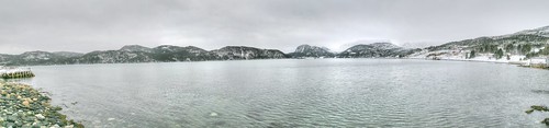
Much to our dismay Newfoundland was experiencing the same warm winter as Vermont... we arrived to barely freezing temperatures and little snow cover on any feature lower than ~1500 feet - even the higher elevations presented thin cover. We spent the first of four nights at Gros Morne Cabins listening to howling wind in excess of 40mph. The wind hadn't abated by morning and looking out into the dark choppy waters of Rocky Harbor cove, it was clear we weren't going to go skiing. We were inspired by a panorama photograph in the convenience store to hike into Western Brook Pond - a small, shallow pond filling an uplifted fjord to the northeast of Rocky Harbor. The Hiking into the pond the temperature dropped, winds increased and frozen precipitation in the form of sleet pellets began to 'fall' sideways. A good sign that skiing was in our future. The northwestern shore of Western Brook Pond was littered with small, think platters of ice and eventually we had to turn back when we discovered there was active Moose hunting in the area in the vicinity of Snug Harbor.
Looking east into Western Brook Pond canyon
From Western Brook we headed north to Cow Head, which is a small island connected to the mainland by a tombolo created by a classic cuspate spit well-armored in places with clasts of varying lithology. Cow Head itself exposes limestone conglomerates, shales and limestone of varying thickness that have been weathered and eroded into steep cliffs and long fins that run parallel with the currents. Instead of hiking for snow we found ourselves enjoying an afternoon of 'extreme tide pooling' in blistering wind carrying shards of ice.
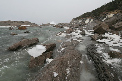
Looking north along the western edge of Cow Head
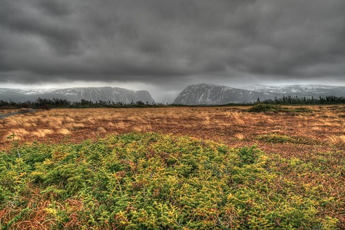
Our second and third days were more successful. The wind calmed down, the temperatures dropped and we could see snow accumulating in the higher elevations. We ventured south towards the Tablelands - a large plateau sheared off by glaciers composed of serpentinized peridotite.
A view looking south across the South Arm of Bonne bay into the Tableands from Woody Point
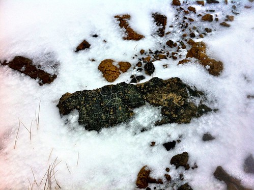
An example of serpentinized peridotite exposed in the slope
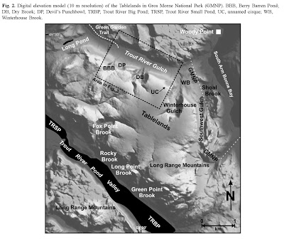
Peridotite is an ultramafic rock derived from the mantle; part of a thin slice of oceanic crust exposed at the earth's surface as part of an Ordovician ophiolite complex. We turned into the first parking lot on the south side of Route 431 just past Winter House Brook and picked our way through a sea of exposed peridotite into an unnamed cirque between Dry Brook and Winter House Brook.
The first day we skinned up and only skied the lower portion of the bowl because of poor visibility and evidence of recent avalanche activity. The second day we skinned up onto the Tableland plateau itself and skied the upper bowl. We took three runs down a moderately steep gully (Osborn et al. described the gullies as fluvial gorges) filled with knee deep powder and returned to the parking lot via a rock slide channel filled with wind-blown snow. The Tablelands area is littered with solifluction lobes, rock slide channels, sporadic rock-glacier debris, patterned ground, and weakly developed moraines. More than anything else, these features are the reason I would like to return in the summer to hike and explore these unique u-shaped valleys exposing serpentine barrens.
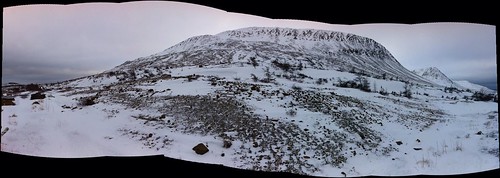
Small panorama looking southeast towards the Tablelands taken from the parking area
I highly recommend a visit to Gros Morne National Park any time of year (even though I haven't yet visited in the summer, it can only be more magnificent). The landscape is breathtaking and the geology is incredibly diverse, ranging from calcareous turbidites near Cow Head, to Grenville age gneisses surrounding Western Brook Pond and the Long Range Mountains, to the volcanics of Green Gardens and peridotite making up the Tablelands. Truly a unique geologic and skiing excursion!
Complete slideshow of photos taken during the Newfoundland trip
Much to our dismay Newfoundland was experiencing the same warm winter as Vermont... we arrived to barely freezing temperatures and little snow cover on any feature lower than ~1500 feet - even the higher elevations presented thin cover. We spent the first of four nights at Gros Morne Cabins listening to howling wind in excess of 40mph. The wind hadn't abated by morning and looking out into the dark choppy waters of Rocky Harbor cove, it was clear we weren't going to go skiing. We were inspired by a panorama photograph in the convenience store to hike into Western Brook Pond - a small, shallow pond filling an uplifted fjord to the northeast of Rocky Harbor. The Hiking into the pond the temperature dropped, winds increased and frozen precipitation in the form of sleet pellets began to 'fall' sideways. A good sign that skiing was in our future. The northwestern shore of Western Brook Pond was littered with small, think platters of ice and eventually we had to turn back when we discovered there was active Moose hunting in the area in the vicinity of Snug Harbor.
From Western Brook we headed north to Cow Head, which is a small island connected to the mainland by a tombolo created by a classic cuspate spit well-armored in places with clasts of varying lithology. Cow Head itself exposes limestone conglomerates, shales and limestone of varying thickness that have been weathered and eroded into steep cliffs and long fins that run parallel with the currents. Instead of hiking for snow we found ourselves enjoying an afternoon of 'extreme tide pooling' in blistering wind carrying shards of ice.
Our second and third days were more successful. The wind calmed down, the temperatures dropped and we could see snow accumulating in the higher elevations. We ventured south towards the Tablelands - a large plateau sheared off by glaciers composed of serpentinized peridotite.
Peridotite is an ultramafic rock derived from the mantle; part of a thin slice of oceanic crust exposed at the earth's surface as part of an Ordovician ophiolite complex. We turned into the first parking lot on the south side of Route 431 just past Winter House Brook and picked our way through a sea of exposed peridotite into an unnamed cirque between Dry Brook and Winter House Brook.
Image from: Osborn et al (2007)
The first day we skinned up and only skied the lower portion of the bowl because of poor visibility and evidence of recent avalanche activity. The second day we skinned up onto the Tableland plateau itself and skied the upper bowl. We took three runs down a moderately steep gully (Osborn et al. described the gullies as fluvial gorges) filled with knee deep powder and returned to the parking lot via a rock slide channel filled with wind-blown snow. The Tablelands area is littered with solifluction lobes, rock slide channels, sporadic rock-glacier debris, patterned ground, and weakly developed moraines. More than anything else, these features are the reason I would like to return in the summer to hike and explore these unique u-shaped valleys exposing serpentine barrens.
I highly recommend a visit to Gros Morne National Park any time of year (even though I haven't yet visited in the summer, it can only be more magnificent). The landscape is breathtaking and the geology is incredibly diverse, ranging from calcareous turbidites near Cow Head, to Grenville age gneisses surrounding Western Brook Pond and the Long Range Mountains, to the volcanics of Green Gardens and peridotite making up the Tablelands. Truly a unique geologic and skiing excursion!